Introduction
GisMap is a .NET component for building GIS and CAM/CAD application. It's a part of MVisionTech VisiWorks data visualization framework. GisMap uses Canvas for drawing geometrical shapes and GDAL project for handling different geographical vector and raster formats.
Maps are essential to locate objects distributed over wide areas. There are many kinds of applications that require geographical presentation of data, such as trip organizers, assets management systems, fleet management, GPS tracking and many others. All these types of system constitute the GIS or Geographical Information System.
A classical GIS system consists of tables with data records related to objects and geometrical shapes representing the objects such as polygons and polylines. Tables in a GIS system represent the different layers in the map. Some layers represent different functional objects such as roads, counties and cities, while others represent different resolutions of the same functional layer such as hi-ways, main roads and all roads. Satellite images and aerial photography are frequently used in combination with other geometrical objects. There are different sources of geographical data, GIS system vendors use different file formats to store data in their system. Some major players in the GIS market are ESRI, MapInfo and Oracle.
GisMap uses the open source library called GDAL (Geographical Data Abstraction Layer) to access different sources of geographical data. GDAL supports most of the raster formats (images) and main vector formats via its OGR library. It also provides classes for geographical coordinate system transformation.
Geographical coordinate system is another story, there are a number of different systems, and some of them are very exotic. The reason is that the Earth is a sphere (well almost) and people like to use square coordinates when they measure things. So for measurements they use the projection of various parts of the sphere on the plane. Then these different projections originated from different places, depending on the state, country or continent is measured.
The most popular coordinate systems are WGS-84 (spherical coordinate system with longitude and latitude) and UTM a system of 60 cylindrical projections of WGS-84.
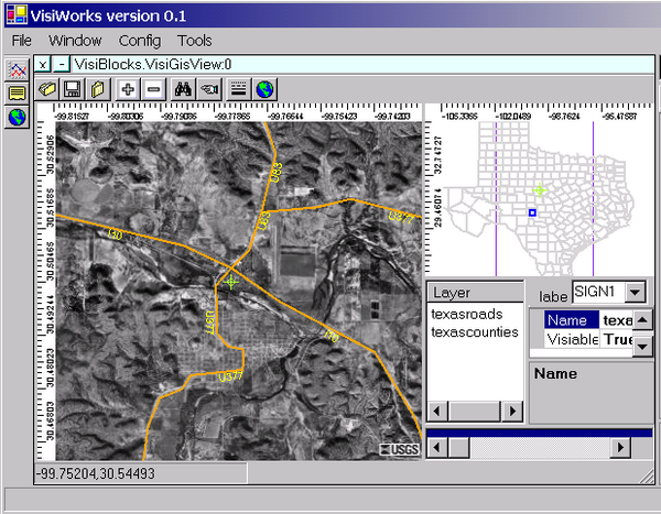
The picture above shows USA's main roads with aerial image somewhere in Texas. When the user zooms in and out the map, GisMap gets the proper image size and resolution from TerraService web services and displays the vector data from the locally stored shape files. Vector data is organized in layers, where each layer corresponds to different map resolutions. GisMap has two different views of the same geographical data, one for navigation and another for browsing. Two views are synchronized; the small blue rectangle on the navigation view shows the location of the second view.
The layer control can be used to adjust the order and visibility of different layers. For every layer the user can specify the minimum and maximum scale to switch from course view to detailed one.

GisMap has a DataGrid showing the attributes of geographical objects in the map, when the map is in "find" mode and an object has been selected GisMap brings a record related to the selected shape.
Using the code
The main purpose of having a Map component is using it in other applications.
Canvas canvasGIS = new Canvas();
...
GisSelector gisSelector = new GisSelector();
gisSelector.setCanvas(canvasGIS);
...
ArrayList al = gisSelector.openGisFile(fname);
...
GeomModel.CanvasLayer lay1 =
new GeomModel.CanvasLayer("geo_image",Color.BlueViolet,0,true);
GDalGIS.GdalImageCanvasItem geo_im =
new GdalImageCanvasItem(im_fname,lay1);
canvasGIS.AddShape(geo_im);
...
GeomModel.CanvasLayer lay2 =
new GeomModel.CanvasLayer("terra_image",Color.BlueViolet,0,true);
TerraService.TerraServiceImage t_im =
new TerraService.TerraServiceImage(
"http:// terraserver-usa.com/ogcmap.ashx",lay2);
this.canvasGIS.AddShape(t_im);
Design
GisMap uses the Canvas component for creating graphics and GDAL data abstraction to access geographical data. For aerial photography, it uses Microsoft's TerraServise, a thing of beauty. It covers the whole of USA with 1m per pixel resolution. GisMap uses OpenGIS Web Map standard (OGC Web Map Server) to access the data.
The class diagram below shows the main classes of GisMap component. It uses the Canvas control and its geometrical model (GeomModel) to display maps and GDAL classes to deal with GIS data, coordinate systems and transformations.
Baranovsky Eduard has been a software developer for more then 10 years. He has an experence in image processing, computer graphics and distributed systems design.


 General
  News
News  Suggestion
  Question
  Bug
Bug  Answer
  Joke
Joke  Praise
  Rant
Rant  Admin
Admin 


 Failed to generate GDAL.DLL due to compiling error of missing header file.
